Showing 54 media items
![Mar 18, 2022:](https://taosavalanchecenter.org/wp-content/uploads/2022/03/Lukes-Pocket-18-Mar-320x240.jpg)
Mar 18, 2022
![Mar 18, 2022:](https://taosavalanchecenter.org/wp-content/uploads/2022/03/Slide1-5-320x240.jpeg)
Mar 18, 2022
![Mar 12, 2022: A Different vantage point of the slide and where the debris ended up](https://taosavalanchecenter.org/wp-content/uploads/2022/03/IMG_1213-320x240.jpeg)
Mar 12, 2022
![Mar 12, 2022: Very Large natural persistent slab avalanche on a NE aspect that happened last night or early this morning. This slope was being loaded over the last 24 hours by moderate to strong winds.](https://taosavalanchecenter.org/wp-content/uploads/2022/03/IMG_1201-320x240.jpeg)
Mar 12, 2022
![Mar 11, 2022:](https://taosavalanchecenter.org/wp-content/uploads/2022/03/Slide1-4-320x240.jpeg)
Mar 11, 2022
![Mar 11, 2022: Crowns that have filled back in that most likely ran early in the storm on Thursday on northerly above treeline terrain.](https://taosavalanchecenter.org/wp-content/uploads/2022/03/IMG_1183-320x240.jpeg)
Mar 11, 2022
![Mar 9, 2022:](https://taosavalanchecenter.org/wp-content/uploads/2022/03/Slide1-1-320x240.jpeg)
Mar 9, 2022
![Mar 3, 2022:](https://taosavalanchecenter.org/wp-content/uploads/2022/03/Slide1-320x240.jpeg)
Mar 3, 2022
![Mar 3, 2022: Warm temperatures and sunny skies over the last several days has resulted in a shrinking snowpack and melt-freeze crusts that quickly soften up throughout the day. There is an obvious dust layer that formed from the 2/22 wind event that is now visible on many solar aspects.](https://taosavalanchecenter.org/wp-content/uploads/2022/03/IMG_1163-2-320x240.jpeg)
Mar 3, 2022
![Feb 27, 2022: A better photo of the large avalanche on East facing ridgeline of Lake Fork that ran naturally during the storm early Thursday morning. North and east-facing terrain are where avalanches can break deeper and wider from the strong westerly winds that loaded these slopes during the storm.](https://taosavalanchecenter.org/wp-content/uploads/2022/02/IMG_1160-2-320x240.jpeg)
Feb 27, 2022
![Feb 27, 2022: Faceted crust beneath the President's week storm](https://taosavalanchecenter.org/wp-content/uploads/2022/02/Slide1-7-320x240.jpeg)
Feb 27, 2022
![Feb 27, 2022:](https://taosavalanchecenter.org/wp-content/uploads/2022/02/Slide1-6-320x240.jpeg)
Feb 27, 2022
![Feb 25, 2022: Natural avalanche on an easterly aspect on the Lake Fork ridgeline. These leeward sides of ridgelines are where we've seen the greatest amount of loading from strong W/SW winds over the last several days](https://taosavalanchecenter.org/wp-content/uploads/2022/02/IMG_1149-320x240.jpeg)
Feb 25, 2022
![Feb 24, 2022:](https://taosavalanchecenter.org/wp-content/uploads/2022/02/Slide1-5-320x240.jpeg)
Feb 24, 2022
![Feb 24, 2022: Shooting cracks were widespread once you got near and above treeline as strong winds were easily transporting snow into stiffening slabs](https://taosavalanchecenter.org/wp-content/uploads/2022/02/IMG_1134-320x240.jpeg)
Feb 24, 2022
![Feb 24, 2022: Small remotely triggered wind slab avalanche near treeline on a slope that was actively loading. It was roughly 50' wide and about 1' foot deep Size 1.](https://taosavalanchecenter.org/wp-content/uploads/2022/02/IMG_1133-320x240.jpeg)
Feb 24, 2022
![Feb 24, 2022: Large Size 2 natural avalanche on a NNE aspect on the backside of Kachina Peak. This most likely ran sometime in the early morning hours on Thursday. This path also ran during the January 1st avalanche cycle. You can see a large crown about halfway down the chute and most likely ran on an old faceted layer.](https://taosavalanchecenter.org/wp-content/uploads/2022/02/IMG_1138-320x240.jpeg)
Feb 24, 2022
![Feb 18, 2022: NW winds early this morning were easily transporting the 4 to 6](https://taosavalanchecenter.org/wp-content/uploads/2022/02/IMG_1118-320x240.jpeg)
Feb 18, 2022
![Feb 18, 2022:](https://taosavalanchecenter.org/wp-content/uploads/2022/02/Slide1-4-320x240.jpeg)
Feb 18, 2022
![Feb 18, 2022: Small pocket the pulled on a steep NE aspect at about 12,000' appears to be more than just the 4 to 6 inches of new snow most likely failing just below a crust that formed prior to the storm](https://taosavalanchecenter.org/wp-content/uploads/2022/02/IMG_1117-320x240.jpeg)
Feb 18, 2022
![Feb 12, 2022:](https://taosavalanchecenter.org/wp-content/uploads/2022/02/Slide1-3-320x240.jpeg)
Feb 12, 2022
![Feb 12, 2022:](https://taosavalanchecenter.org/wp-content/uploads/2022/02/Slide1-2-320x240.jpeg)
Feb 12, 2022
![Feb 12, 2022: Winds this morning were drifting the 1 to 2 inches of snow that fell last night at upper elevations](https://taosavalanchecenter.org/wp-content/uploads/2022/02/IMG_1109-2-320x240.jpeg)
Feb 12, 2022
![Feb 9, 2022: Cross-loaded wind drifted slope on a NE Aspect, It's on wind affected slopes that you are more likely to find a stiffer cohesive slab able to propagate and fail on facets below](https://taosavalanchecenter.org/wp-content/uploads/2022/02/IMG_1103-320x240.jpeg)
Feb 9, 2022
![Feb 9, 2022:](https://taosavalanchecenter.org/wp-content/uploads/2022/02/Slide1-1-320x240.jpeg)
Feb 9, 2022
![Feb 5, 2022: Shooting Cracks after I approached a NE aspect Near Treeline and had a loud audible collapse](https://taosavalanchecenter.org/wp-content/uploads/2022/02/IMG_1101-320x240.jpeg)
Feb 5, 2022
![Feb 5, 2022:](https://taosavalanchecenter.org/wp-content/uploads/2022/02/Slide1-320x240.jpeg)
Feb 5, 2022
![Feb 5, 2022: Natural avalanches that ran sometime during the storm on Wednesday.
Photo: Leland Thompson](https://taosavalanchecenter.org/wp-content/uploads/2022/02/IMG_0913-preview-320x240.jpeg)
Feb 5, 2022
![Feb 3, 2022: Natural loose snow avalanches on the backside of Kachina Peak (NE Aspect) that started as loose snow sluffs up high in the rocks and peeled pockets of storm slabs further down in the track.](https://taosavalanchecenter.org/wp-content/uploads/2022/02/IMG_1086-320x240.jpeg)
Feb 3, 2022
![Feb 3, 2022: Long-running natural loose snow avalanches on Sin Nombre Peak (N Aspect)](https://taosavalanchecenter.org/wp-content/uploads/2022/02/IMG_1088-320x240.jpeg)
Feb 3, 2022
![Feb 3, 2022: Recent natural avalanche activity that started as smaller point releases and stepped down propagating small storm slab avalanches on steep NE terrain above treeline](https://taosavalanchecenter.org/wp-content/uploads/2022/02/IMG_1092-320x240.jpeg)
Feb 3, 2022
![Jan 27, 2022: Quick snowpit from Lake Fork Peak (NNE aspect above treeline) that shows the 4 inches of low-density snow from Tuesday evening/Wednesday mornings storm on top of a supportable wind crust that formed in the middle of January. An additional 4 inches of snow fell overnight with moderate winds in the teens gusting in the 20 mph range.](https://taosavalanchecenter.org/wp-content/uploads/2022/01/IMG_1073-320x240.jpeg)
Jan 27, 2022
![Jan 27, 2022: Loose-dry snow sluffs from the recent low-density new snow will be a concern with warming temperatures today and sun on Steep slopes.](https://taosavalanchecenter.org/wp-content/uploads/2022/01/IMG_1071-320x240.jpeg)
Jan 27, 2022
![Jan 20, 2022: A couple of inches of low-density new snow fell on a variety of different surfaces from firm crusts to near-surface facets. Small loose snow avalanches started as point releases in steep terrain fanning out. With more snow in the forecast, these old snow interfaces will become more important in the coming days.](https://taosavalanchecenter.org/wp-content/uploads/2022/01/IMG_1063-320x240.jpeg)
Jan 20, 2022
![Jan 20, 2022: Shallow snowpack on a northerly aspect above treeline. Its places where you find shallow snowpacks like this that you're more likely to impact faceted layers near the ground](https://taosavalanchecenter.org/wp-content/uploads/2022/01/Slide1-3-320x240.jpeg)
Jan 20, 2022
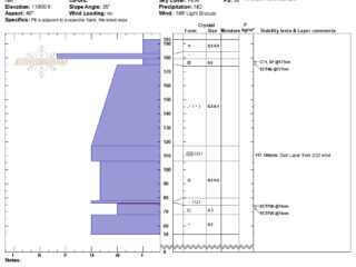
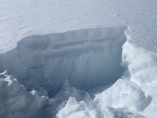
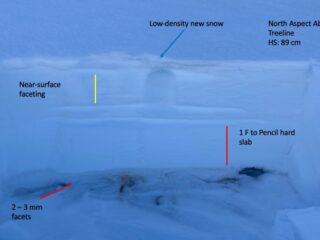
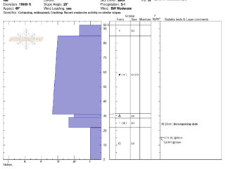
![Jan 13, 2022: NE aspect near treeline in Long Canyon. (HS: 115cm) ECTX (no result) with extended column tests. Near surface faceting in the upper 10-20cm of the snowpack with stiffer slabs above […]](https://taosavalanchecenter.org/wp-content/uploads/2022/01/IMG_1060-320x240.jpeg)
Jan 13, 2022
![Jan 11, 2022:](https://taosavalanchecenter.org/wp-content/uploads/2022/01/Yours-and-Mine-11-Jan-320x240.jpg)
Jan 11, 2022
![Jan 11, 2022:](https://taosavalanchecenter.org/wp-content/uploads/2022/01/Slide1-2-320x240.jpeg)
Jan 11, 2022
![Jan 11, 2022:](https://taosavalanchecenter.org/wp-content/uploads/2022/01/Slide1-1-320x240.jpeg)
Jan 11, 2022
![Jan 7, 2022: Dug a pit in a shallow snowpack on NE aspect above treeline. It's this shallow snowpacks where you're most likely to impact a depth hoar layer on the ground](https://taosavalanchecenter.org/wp-content/uploads/2022/01/Slide1-320x240.jpeg)
Jan 7, 2022
![Jan 7, 2022:](https://taosavalanchecenter.org/wp-content/uploads/2022/01/Lake-Fork-07-Jan-320x240.jpg)
Jan 7, 2022
![Jan 2, 2022: Another very large natural persistent slab avalanche on Vallecito Ridgeline. Multiple fracture lines. It appears like most of the Vallecito ridgeline that faces north ran naturally during the storm
Photo Alex M](https://taosavalanchecenter.org/wp-content/uploads/2022/01/IMG_1029-320x240.jpeg)
Jan 2, 2022
![Jan 2, 2022: Very large natural avalanche on the North Face of Vallecito ridgeline that happened sometime early morning Friday during the storm
Photo Alex M](https://taosavalanchecenter.org/wp-content/uploads/2022/01/IMG_1025-1-320x240.jpeg)
Jan 2, 2022
![Jan 2, 2022: NE aspect on the backside of Kachina Peak](https://taosavalanchecenter.org/wp-content/uploads/2022/01/IMG_1023-320x240.jpeg)
Jan 2, 2022
![Jan 2, 2022: Natural PS avalanches on E and NE aspects on Kachina Peak](https://taosavalanchecenter.org/wp-content/uploads/2022/01/DSC01942-320x240.jpeg)
Jan 2, 2022
![Dec 30, 2021: ENE aspect near treeline with about a foot of low-density fist hard snow from the 12/29 storm on top of the denser slab from Christmas Eve storm. Basal facets from earlier snow continue to linger near the ground.](https://taosavalanchecenter.org/wp-content/uploads/2021/12/Slide1-2-320x240.jpeg)
Dec 30, 2021
![Dec 27, 2021: Large natural avalanche on North Aspect above treeline running into the flats](https://taosavalanchecenter.org/wp-content/uploads/2021/12/IMG_0993-320x240.jpeg)
Dec 27, 2021
![Dec 25, 2021:](https://taosavalanchecenter.org/wp-content/uploads/2021/12/Slide1-320x240.jpeg)
Dec 25, 2021
![Dec 25, 2021: Shooting cracks in the foreground with a crown in the background from a natural avalanche sometime Friday night. NE aspect at 11,200'](https://taosavalanchecenter.org/wp-content/uploads/2021/12/IMG_0983-320x240.jpeg)
Dec 25, 2021
![Dec 25, 2021:](https://taosavalanchecenter.org/wp-content/uploads/2021/12/No-Name-Near-Treeline-25-Dec-320x240.jpg)
Dec 25, 2021
![Dec 22, 2021: Lake Fork Peak (NNE aspect) has some of the most continuous snow in the range. These northerly and east-facing slopes will become increasingly dangerous with new snow in the forecast adding a slab on top of a weak faceted snowpack](https://taosavalanchecenter.org/wp-content/uploads/2021/12/IMG_0975-320x240.jpeg)
Dec 22, 2021
![Dec 22, 2021: Shallow weak faceted snowpack](https://taosavalanchecenter.org/wp-content/uploads/2021/12/IMG_0972-320x240.jpeg)
Dec 22, 2021
![Dec 22, 2021: West facing slope with not much snow in chute](https://taosavalanchecenter.org/wp-content/uploads/2021/12/IMG_0970-320x240.jpeg)
Dec 22, 2021
![Dec 20, 2021: 100 + mph winds from last weeks storm did a lot of damage to the forests](https://taosavalanchecenter.org/wp-content/uploads/2021/12/IMG_0977-320x240.jpeg)
Dec 20, 2021