Professional Observation
Basic Information
Observation Details
Observation Date:
December 4, 2025Submitted:
December 4, 2025Observer:
TAC - Andy BondZone or Region:
Taos AreaLocation:
Early Season Conditions Taos AreaSigns of Unstable Snow
Recent Avalanches?
YesCracking?
None ExperiencedCollapsing?
None ExperiencedBottom Line
12 to 16 inches of low density snow fell over the last 5 days with light winds. This new snow fell on top of faceted snow that formed from earlier storms in November. In isolated pockets on steep northerly and east aspects at upper elevations you can find enough of a reactive slab to get to fail on facets 20 to 30 cm down from the surface.
Overall the snowpack is still very shallow with ski penetration to the ground making travel difficult. Winds are expected to pick up on Saturday 12/6 and we may see stiffer more reactive slabs form at upper elevations.
Advanced Information
Weather Summary
Cloud Cover:
OvercastTemperature:
16Wind:
Light , SWLight snowfall S-1 with nothing accumulating. When visibility allowed, we noticed some snow transporting at the upper ridgelines.
Avalanche Observations
We did have a report of a small (D1) skier triggered avalanche from avalanche control teams in steep northerly facing terrain.
Snowpack Observations
It's still a shallow and thin snowpack (about 2 foot depth) that's not very supportable, making skiing or riding difficult with lots of ground hazards.
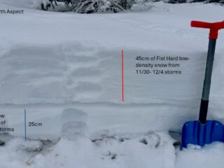
Two storms over the last week ( 11/30-12/1: 4 to 6" of snow with 0.375" of SWE; and 12/3: 10" of snow and 0.5" of SWE) has brought low density snow with light winds and cold temperatures. This new snow fell on top of 20 to 30 cm of faceted snow from storms in the middle of November. In our travels over the last several days, we have not had this low-density snow be reactive in long column tests as it is not enough of a slab to propagate. We have a weak layer right now (facets that formed from the middle of November snow) but most slopes right now don't have a widespread slab on top for slab avalanches. This could change in the coming days especially if the wind picks up, but right now the biggest hazard continues to be ground hazards.
With that being said, you may find isolated pockets at upper elevations where even a little bit of wind has created enough of a slab to propagate. Unfortunately, it looks like we'll be heading into a prolonged period of high pressure through the middle of the month. If you are getting out the key will be seeing if anything has changed our low density snow into the missing ingredient on most slopes (the slab). Here are a couple of things I'll be monitoring:
- Increasing winds, that will easily transport the low density snow into cohesive slabs. (Winds look to increase on 12/6)
- The low density snow settling and stiffening into more of a cohesive slab during this upcoming period of high pressure.
- Sun and warmer temperatures bringing small loose snow avalanches in steep terrain within the cohesionless snow.
The long term does not look great for us, with storms tracking to our north in long range models. Our shallow snowpack will change during this time, most likely faceting throughout, and we may see some depth hoar development as cold temperatures drive a strong temperature gradient.
Avalanche Problems
| Problem | Location | Distribution | Sensitivity | Size | Comments |
|---|---|---|---|---|---|
 Persistent Slab
|
|
Layer Depth/Date: 25 to 40 cm below the surface |
This problem is isolated and pocketed to steep northerly and east aspects at upper elevations where there's been enough wind to stiffen the new low density snow into a stiff enough slab. These slabs will fail on the interface of the mid-November snow and 11/30 storm snow. These avalanches would be small but would lead to nasty ride over rocks and downed trees.
Terrain Use
Survival skiing with ski penetration to the ground.
Close