Professional Observation
Basic Information
Observation Details
Observation Date:
February 19, 2025Submitted:
February 19, 2025Observer:
TAC - Andy BondZone or Region:
Taos AreaLocation:
Natural and Human Triggered AvalanchesSigns of Unstable Snow
Recent Avalanches?
YesCracking?
WidespreadCollapsing?
WidespreadSnow Stability
Stability Rating:
PoorConfidence in Rating:
HighStability Trend:
Bottom Line
Dangerous avalanche conditions continue to exist, especially on North and East aspects
Advanced Information
Weather Summary
Cloud Cover:
Mostly SunnyTemperature:
15 - 32Wind:
Moderate , SWSunny day with moderate SW winds at ridgelines. A little bit of snow was transporting onto East aspects during the day.
Avalanche Observations
| # | Date | Location | Size | Type | Bed Sfc | Depth | Trigger | Comments | Photo |
|---|---|---|---|---|---|---|---|---|---|
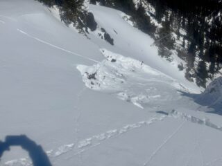
| 1 | Today |
Middle Fork Drainage E Near Treeline |
D2 | SS | O-Old Snow | 2 feet |
AS-Skier c-Intentional |
First slope we touched today, an east aspect near treeline. Got a collapse near the ridgeline and triggered this Persistent Slab avalanche that failed on depth hoar near the ground. This avalanche path has run already this year. |
|
Snowpack Observations
The angry inch of snow with a little bit of wind has made slopes even more reactive than what they were. It's hard to put into words how fragile our weak layers are, but our setup this year has been pretty strange. We had historic levels of snowfall in our range up until November 8th. Then we went close to 90 days with only a couple of small low-density storms. Over that time, our 2 to 3 foot snowpack turned into large grain Depth Hoar. Typically, 3 - 6mm but have seen over 10mm in some pits. Recent strong winds and dense heavy snow have created cohesive slabs over this incredibly faceted weak layers.
6-8" of snow isn't much (barely a powder day) As avalanche forecasters we don't care as much about how much snow we get compared to how much water weight and density of the snow. The bigger storm at the end of January that brought us 16" of snow and .7" of SWE came in with no wind. That's only 4.3% density, which may be even lighter than Alta sees. It was way more snow but about 1/2 the amount of weight, plus there wasn't any wind to transport snow into more cohesive slabs. This last storm, 6-8" of snow and 1.2–1.4" of SWE and had 60 mph winds during it was the exact opposite. This slab formation and weight of the slab on top is what's driving the touchy avalanche conditions right now.
We're about ready to head into another weird part of our "winter" with another round of record-breaking high temperatures on Monday and Tuesday.
Weird weather, weird winter, and now we're seeing prolonged elevated avalanche conditions 5 days after a storm with only an inch of snow and some wind.
Avalanche Problems
| Problem | Location | Distribution | Sensitivity | Size | Comments |
|---|---|---|---|---|---|
 Persistent Slab
|
|
A little bit of loading and we observed natural avalanches on the East facing slopes in Long Canyon as well as easily triggered a persistent slab avalanche on an east aspect near treeline in the middle fork drainage. Cracking and collapsing continues to remain widespread. Our persistent weak layers are incredibly fragile and are struggling with even a small amount of loading.
Terrain Use
We're not touching, being on or under anything over 35 degrees.
Close