Professional Observation
Basic Information
Observation Details
Observation Date:
January 24, 2025Submitted:
January 25, 2025Observer:
TAC - Andy BondZone or Region:
Taos AreaLocation:
Small wind slabs formingSigns of Unstable Snow
Recent Avalanches?
None ObservedCracking?
IsolatedCollapsing?
IsolatedMedia
Advanced Information
Weather Summary
Cloud Cover:
ClearTemperature:
16 - 28Wind:
Moderate , SWFinally a warm sunny day, after below 0 F temps for days. Although the wind was moderate, we didn't observe snow transporting today.
Snowpack Observations
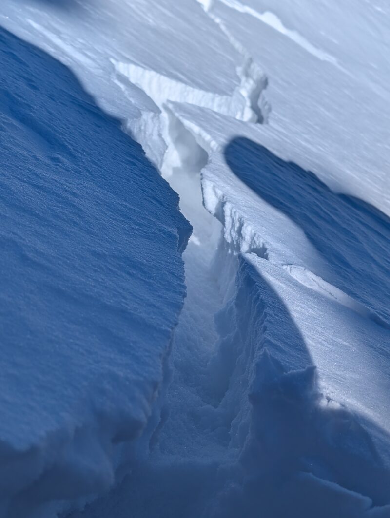
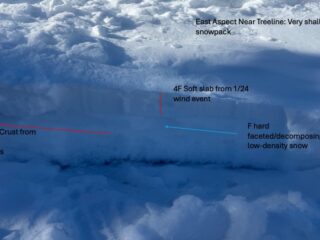
There's finally something interesting to look at, besides the very large depth hoar crystals. We had some big "historic" storms very early in the season and after close to 3 months of dry weather (15 inches of low-density snow over that time) we're seeing shallow soft slabs form from moderate to strong winds that have drifted the low-density snow over the last 10 days. These slabs were reactive to cracking and collapsing on the test slopes we traveled on, however we weren't finding enough weight or depth of the slabs to overcome friction to produce an avalanche.
As we continue to wait for that significant snow storm (hopefully starting Wednesday), these obs and conditions should be a warning sign of things to come if we do see that storm.
I'm going to remain reserved after having looked at long range models this winter and storms track to our south or north, but the hope is that we'll see another significant system move into our are Wednesday potentially into the weekend as slow moving cut-off low from CA makes it way through NM. There's still a ton of details to be sorted out, but there's hope.
Unfortunately, although we'll be excited about fresh powder it also means we'll see a dramatic increase in avalanche danger once we do see significant snow.
Avalanche Problems
| Problem | Location | Distribution | Sensitivity | Size | Comments |
|---|---|---|---|---|---|
 Wind Slab
|
|
We were finding shallow soft winds slabs mainly just below ridgelines and more than likely cross-loaded terrain features. This included some more wind exposed below treeline terrain. Although we weren't able to trigger an avalanche on a couple of test slopes most likely due to not having enough weight and depth of a slab, were were getting widespread collapsing and cracking in places we found slabs. | |||
 Persistent Slab
|
|
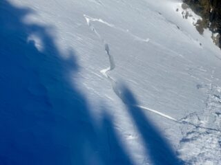
W/SW winds last drifted low-density snow into soft slabs that was just talked about in the wind slab problem. Although we were finding these slabs to fail just below the slab, some slopes have 30-80cm of mainly faceted/depth hoar snow. We had a report today of a natural avalanche above treeline that broke near the ground. Avalanches that might initially fail near the surface could also step down or gouge into the very weak snow that exists throughout the snowpack. | |||
 Dry Loose
|
|
Many slopes don't have a slab on top with a snowpack consisting of mainly faceted/depth hoar snow throughout. This is typically 45 - 80cm deep. In steep terrain you can produce a small dry loose snow avalanche. Although not all that concerning, it could knock you off your feet and be problematic in consequential terrain. |
Terrain Use
Finally are starting to have avalanche conditions worth talking about. We were trying to see how reactive newly formed wind slabs were. We still have a bit to wait, and I'm tired of looking a weather models hoping storms will come our way, but we're getting ready for our first significant storm since Nov 5-8th hopefully sometime middle of next week.
Close