Professional Observation
Basic Information
Observation Details
Observation Date:
February 8, 2024Submitted:
February 9, 2024Observer:
TAC - Charles HarrisonZone or Region:
Taos AreaLocation:
No Name Peak AreaSigns of Unstable Snow
Recent Avalanches?
YesCracking?
IsolatedCollapsing?
IsolatedSnow Stability
Stability Rating:
PoorConfidence in Rating:
ModerateStability Trend:
SteadyBottom Line
The avalanche danger is pretty darn spooky out there right now. It's clear that large natural and human-triggered avalanches are likely right now and will continue to occur over the next few days of significant snow and wind. The biggest concern for me is the consequence factor. Our early season weak layers are still really weak and they're buried beneath a really large slab, much of which has been built and compacted over the last week of heavy snowstorms. Between the natural avalanches we've seen in the last several days and the test results we've been getting in our pits, it's pretty clear that we can still impact these weak layers in our travels and thus it's possible to trigger something catastrophic.
Media
Advanced Information
Weather Summary
Cloud Cover:
ObscuredTemperature:
10-15Wind:
Moderate , SWIt was lightly stormy in our area today. We had light snowfall with a few heavier moments (up to S1) and some blowing snow with the southwest winds circulating around the canyon. Snow accumulation was perhaps 2 inches over the course of our 4 hour tour.
Avalanche Observations
| # | Date | Location | Size | Type | Bed Sfc | Depth | Trigger | Comments | Photo |
|---|---|---|---|---|---|---|---|---|---|
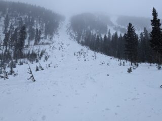
| 1 | Past 24 hours |
Peace Sign W 12,200-10,700 |
D3 | HS | O-Old Snow | 3+ Feet | N-Natural | The avalanche debris had a trace of new snow covering it, so we think it occurred late yesterday or overnight. The debris pile was easily 100m across and several feet deep, and ran completely over and about 100 feet past that section of the Williams Lake Trail. We saw a number of freshly snapped trees in the path. From below, it looked like the slide started as a smaller avalanche close to the ridgeline and stepped down to the ground near the top of the chute where it starts to narrow. This was definitely a size 3. |
|
Snowpack Observations
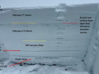
Profile 1: N aspect, below treeline, 11,500 feet
HS 140cm
ECTP 21, failed on the depth hoar
PST 23/150 END on the depth hoar
PSTV
Here we had a good example of wind-sheltered snow below treeline. It was concerning to us that we were able to get full propagation on the depth hoar with nearly 110cm of snow covering it in this spot. The two subsequent PSTs confirmed our suspicion that the depth hoar is still incredibly weak.
Profile 2: N aspect, above treeline, 11,900 feet
HS 150-180cm
ECTP 21 on early Jan. draught layer
PST 47/200 END x2 on the depth hoar
Once again, this pit gave us the impression that we could still easily impact the early season weak layers, despite the fact that the snowpack is deeper and the slab is generally harder up here. Especially once you consider the fact that wind/storm slabs exist and will continue to grow above treeline over the next few days, it's pretty clear that stepping out onto steeper terrain in the higher alpine is a recipe for disaster. We have a confluence of avalanche problems near and above treeline and I think it's wise to consider that triggering the smaller problem is an excellent way to trigger the larger, more destructive one.
Terrain Use
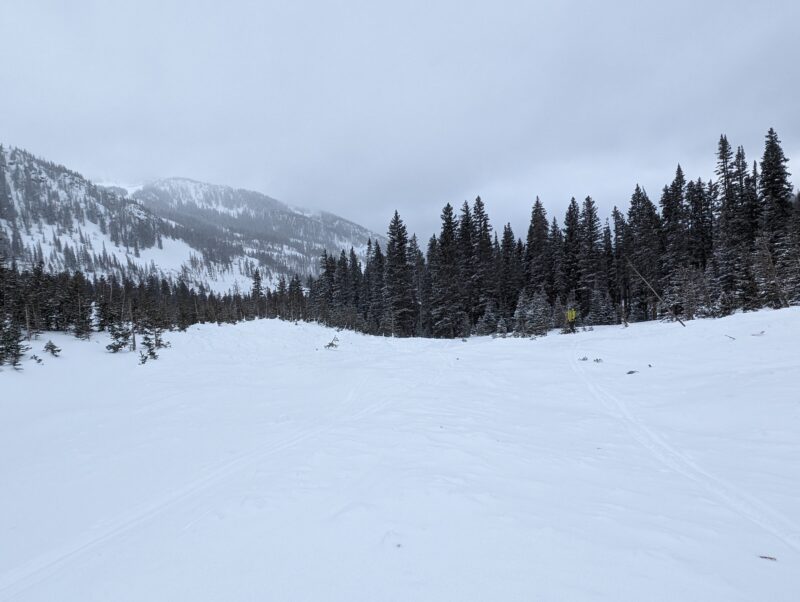
Terrain Choice. We stuck to lower-angle tree skiing today. Fact of the matter is: it's pretty darn good at the moment thanks to all of the new snow we've had lately! We're viewing it as a worthy replacement for getting close to anything steep right now.
Close