Professional Observation
Basic Information
Observation Details
Observation Date:
March 9, 2022Submitted:
March 9, 2022Observer:
TAC - AndyZone or Region:
Taos AreaLocation:
Persistent Slab and Wind Slab Avalanche ProblemsSigns of Unstable Snow
Recent Avalanches?
YesCracking?
IsolatedCollapsing?
IsolatedSnow Stability
Stability Rating:
PoorConfidence in Rating:
HighStability Trend:
WorseningBottom Line
It's been a week of incremental loading and the persistent weak layers are still well preserved 2 to 4 feet below the surface. We haven't hit the tipping point yet but potentially will get there tomorrow with this incoming storm bringing upwards of a foot of snow and wind. Expect new storm snow instabilities as well as deeper weak layers to become more reactive tomorrow as the storm intensifies.
Media
Advanced Information
Weather Summary
Cloud Cover:
ObscuredTemperature:
10 - 25Wind:
Moderate , SWLight snowfall throughout the day S-1 with little to no accumulation above 10,000'. Winds were light below treeline and blowing 10 to 20 with gusts approaching 30 at upper elevations. Snow was being transported at these upper elevations.
Avalanche Observations
Visibility wasn't great but did observe some small loose snow sluffs. Didn't make to ridgelines but did get reports of explosive controlled wind slabs above treeline.
Snowpack Observations
We've been incrementally loading these weak layers without delivering the big knockout punch. Sorry my forecast Monday and this morning have been lacking as I get in a better headspace, but if you look at snowfall over the last 6 days that we've gotten snow it breaks down like this:
All these are measured manually at Poco Gusto between 5 -8 AM depending on when the patrol is in for control work
3/5: 5" of snow with .5" of SWE
3/6: 3" of snow with .2" of SWE
3/7: 13" of snow with 1" of SWE
3/8: 13" of snow with .9" of SWE
3/9: 0" of snow
Winds haven't been incredibly strong during this time frame with a brief spike in winds early morning on 3/6 with wind gusts in the 60 mph. WInds are currently picking a head of this next system.
I suspect we are getting close to a tipping point on many slopes with this incoming storm which could be the largest we've seen over the last week.
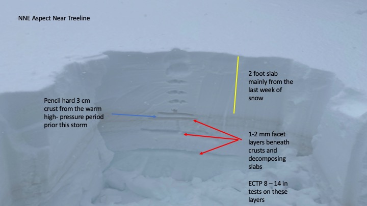
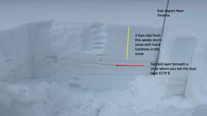
In travels, I wasn't seeing any natural persistent slab avalanche activity when brief periods of visibility came throughout the day. but I was getting easy to moderate results in extended column tests. If you do dig a pit, you will need to dig down below the obvious dust layer in the snowpack which is 2 to 4 feet down to get to the faceted weak layers.
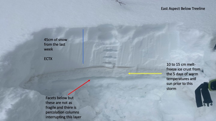
I was observing a thin crust at lower elevations on solar aspects from the brief bit of sun we had yesterday. Cold temperatures are helping with small-grained facets or low-density snow that could be a problematic layer for storm slabs if this storm does produce 12 to 18 inches with wind.
The warm temperatures and sun before this storm have created varying thicknesses of melt-freeze crusts. South and some west and east aspects at lower elevations have thick ice that is 10-15cm thick with percolation columns beneath. I suspect these crusts will be able to handle additional weight but you won't know unless you dig down. In many pits today, northerly and shady aspects below treeline are the most suspect. Near treeline terrain continues to remain the sweet spot as crust facet layers are not as robust and most likely will not hold the weight as well from this incoming storm. Areas above treeline have been a mixed bag and not as widespread with the continuity of the weak layers that a buried beneath slabs. We've seen a lot of repeat runners this year for avalanches and these are also the slopes getting the most amount of loading. If we don't tip the scales at upper elevations, it most likely will take hitting a sweet spot or likely trigger point near rock outcropings or were the slab is thinner.
Avalanche Problems
| Problem | Location | Distribution | Sensitivity | Size | Comments |
|---|---|---|---|---|---|
 Persistent Slab
|
|
Northerly and East aspects seem to be the most widespread with reactive faceted weak layers but I've included west and SE aspects to the rose. Depending on how thick the melt-freeze crust is and how much weight it can handle will play a big role in whether we'll see avalanches on these aspects, but there is a level of uncertainty from slope to slope.
Close