Professional Observation
Basic Information
Observation Details
Observation Date:
February 24, 2022Submitted:
February 24, 2022Observer:
TAC - AndyZone or Region:
Taos AreaLocation:
Wind Slab and Persistent Slab AvalanchesSigns of Unstable Snow
Recent Avalanches?
YesCracking?
WidespreadCollapsing?
IsolatedSnow Stability
Stability Rating:
Very PoorConfidence in Rating:
HighStability Trend:
SteadyBottom Line
Conditions are touchy out there as strong swirling winds drift snow into sensitive slabs mainly near and above treeline. These wind slabs are failing on the old snow/new snow interface that is predominately firm hard crusts or wind slabs. Facets that formed prior to this storm rest just beneath these crusts and slabs which is creating our persistent slab problem. WInd blown snow will help push us closer to a tipping point on many slopes, and although we haven't seen a widespread natural avalanche cycle so far, dangerous avalanche conditions exist and will probably stick around for a little while.
Media

Advanced Information
Weather Summary
Cloud Cover:
ObscuredTemperature:
-4 to 15Wind:
Strong , WVery cold day with temperatures below 0F and in the single digits. Light snow and graupel through the morning S-1 snowfall rate. West winds were in the 20 - 30 mph range gusting in the 40s and were easily transporting snow. Although prevailing winds are out of the west, the box canyon effect was creating swirling winds. Hard to fully gauge how much snow fell overnight due to the wind but 10 to 14 inches sounds about right.
Avalanche Observations
| # | Date | Location | Size | Type | Bed Sfc | Depth | Trigger | Comments | Photo |
|---|---|---|---|---|---|---|---|---|---|
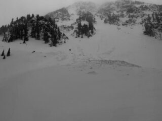
| 1 | Today |
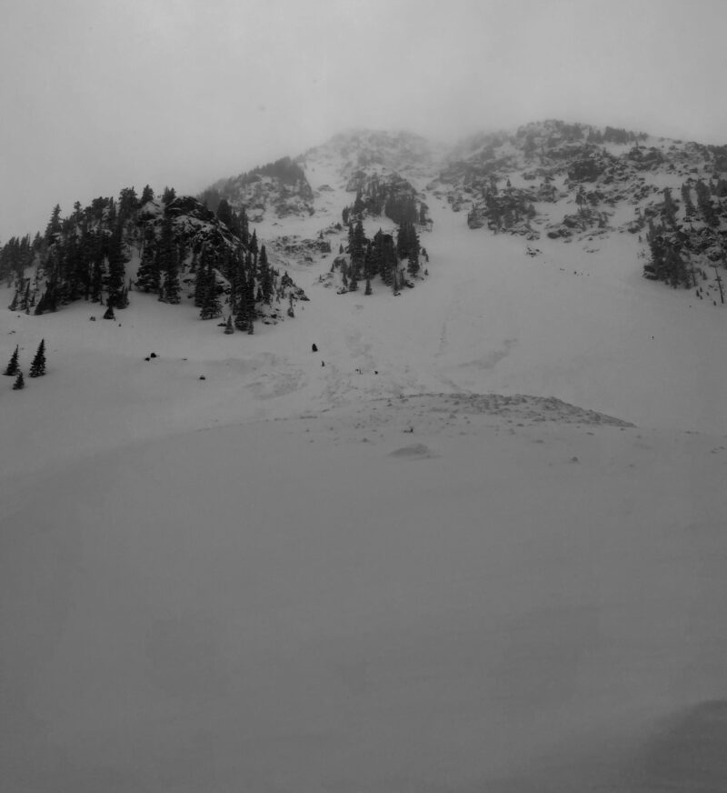
Kachina Peak NE 12,000' |
D2 | SS | O-Old Snow | N-Natural |
|
||
| 1 | Today |
SW 11,500' |
D1 | SS | I-New/Old Interface | 25 cm |
AS-Skier r-Remote |
|
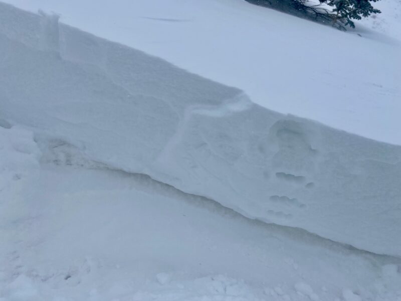
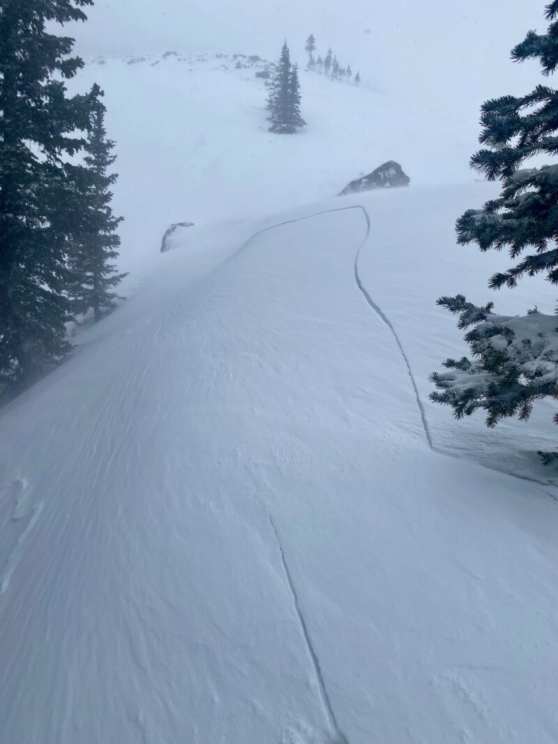
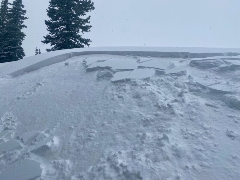
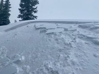
Visibility was tough to come by, but did observe some avalanche debris in the aprons, but not able to see crowns except for the one on Kachina Peak. I triggered 2 small wind slab avalanches on near treeline test slopes, one of which was remotely triggered from 100' away. These wind slabs were failing at the old snow/new snow interface on facet/density changes above crusts or hard slabs from prior wind events.
Snowpack Observations
A dynamic day with weather and avalanche conditions. It was not a widespread natural avalanche cycle as snow totals and SWE was not enough to completely tip the scales which is why I held off on the Avalanche Warning.
Below treeline, there are about 10 inches of new snow, that is being blown around even at these lower elevations. At these elevations is where I was getting loud audible whumpfs, but was not able to trigger avalanches on steep test slopes. We haven't tipped the scales at these elevations, but faceted weak layers beneath these soft slabs are showing signs of being more reactive. It may take a little more wind and loading or some stiffening of the slab for avalanches activity to increase at these elevations.
Near and above treeline, winds are easily transporting snow into more reactive stiffening slabs. I was experiencing widespread cracking and remotely triggering wind slab avalanches that were failing on the old snow interface. Prior to this storm strong winds and warm sunny days created firm surfaces that these slabs rest on top of. These slabs were anywhere from 1 to 3 feet deep.
Did notice an obvious dust layer that most likely formed during Wednesday's strong winds that were 80 mph at ridgetops.
Did not make it to above treeline ridgelines but would imagine wind slabs are easily over 2 feet deep and seeing the most loading on the leeward sides of ridgelines and cross-loaded gullies that most likely will be testing deeper faceted layers.
Avalanche Problems
| Problem | Location | Distribution | Sensitivity | Size | Comments |
|---|---|---|---|---|---|
 Wind Slab
|
|
Strong swirling winds are helping drift new snow into sensitive wind slabs that are very reactive failing on the old firm surfaces that existed prior to this storm. | |||
 Persistent Slab
|
|
I was getting this layer to collapse mainly below and near treeline where the crust or old wind slab is thinner and easier to get to collapse. The avalanche off of the backside of Kachina ran on old faceted snow and I suspect with better visibility tomorrow we may see some more natural avalanches on persistent weak layers. |