Professional Observation
Basic Information
Observation Details
Observation Date:
February 14, 2021Submitted:
February 14, 2021Observer:
TAC - Andy BondZone or Region:
Taos AreaLocation:
No Name to Ring FingerSigns of Unstable Snow
Recent Avalanches?
YesCracking?
None ExperiencedCollapsing?
None ExperiencedSnow Stability
Stability Rating:
FairConfidence in Rating:
ModerateStability Trend:
ImprovingMedia
Advanced Information
Weather Summary
Cloud Cover:
OvercastTemperature:
5 - 10Wind:
Light , SWLight snowfall throughout the day with maybe an inch of accumulation. Winds were light mainly in the single digits with gusts in the teens out of the SW. We did not observe any snow being transported, but visibility was not the best. There is a lot of low density snow available for transport.
Snowpack Observations
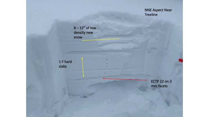
It seemed like we picked up 8 to 12 inches of snow with most of it low-density blower powder. It was some of the best skiing we've had all year today! Wind prone slopes had stiffer more cohesive slabs that formed over crusts and firm surfaces. Leeward sides of ridgelines and cross-loaded terrain features are the most suspect right now as they've seen the most loading and enough cohesion to be able to propagate.
Below Treeline: the snowpack is still incredibly weak with ski and pole penetration all the way to the ground as most of the snowpack consists of facets. Surprisingly we did not observe any collapsing and cracking today in our travels.
Near Treeline: Is a mixed bag with non-wind prone slopes similar to below treeline, consisting of a shallow weak faceted snowpack. Other slopes that open and exposed to winds or are approaching above treeline are deeper with settled cohesive slabs in deeper snowpack with faceted weak layers that are harder to impact. Some of these slopes have stiffer slabs from the 20 mph winds last night during the storm and have stiffening storm slabs that are more reactive.
Above treeline: Winds during the storm have stiffened slabs that are sitting on top of firm surfaces that formed from last weeks winds. Faceted weak layers continue to persist deeper down in the snowpack but would be hard to impact. If you did though and was able to get the slope to fail it would be a very large avalanche.
Avalanche Problems
| Problem | Location | Distribution | Sensitivity | Size | Comments |
|---|---|---|---|---|---|
 Wind Slab
|
|
Mainly above treeline on the leeward side of ridgelines and cross-loaded terrain. Pay attention to the changing of the snow surface. | |||
 Persistent Slab
|
|
Difficult to trigger but if you did, would most likely take most of the season's snowpack with it. Stability tests continue to show these deeper weak layers able to propagate with moderate to hard force. |