Professional Observation
Basic Information
Observation Details
Observation Date:
January 19, 2021Submitted:
January 19, 2021Observer:
TAC - Steve GatelyZone or Region:
Taos AreaLocation:
North and East Aspects Near TreelineSigns of Unstable Snow
Recent Avalanches?
YesCracking?
WidespreadCollapsing?
WidespreadSnow Stability
Stability Rating:
PoorConfidence in Rating:
ModerateStability Trend:
SteadyBottom Line
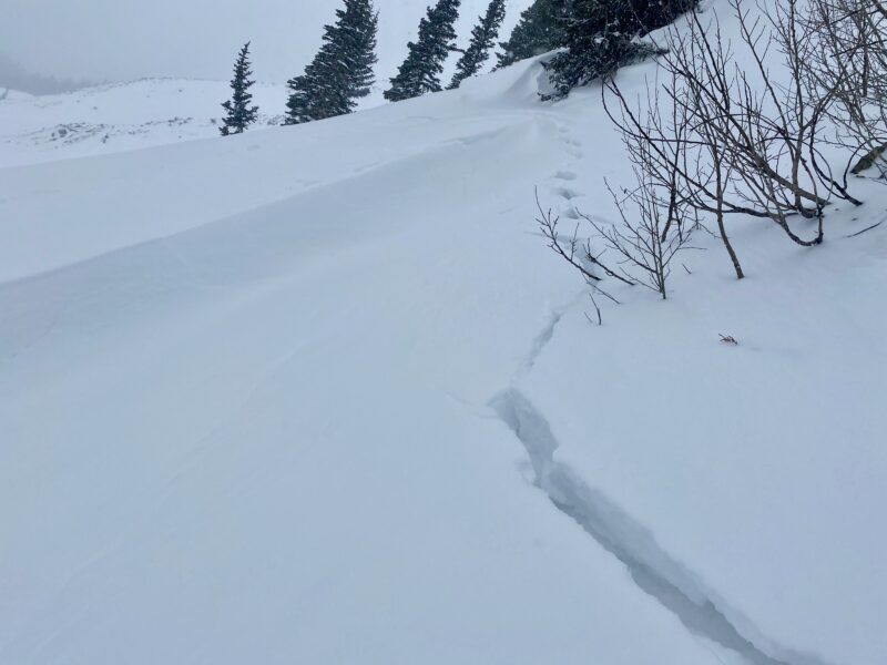
We observed 4 to 6 inches of new snow near and above treeline. Below treeline you can expect to find closer to 2 to 4 inches. We found 4 to 6 inches to be enough to stress our current snowpack and signs of this were evident where we went looking. South/Southeast winds have drifted snow in unusual places but it's easy to spot from a distance. We found drifts up to 12 inches in depth. We found two test slopes with wind drifted snow and one slope collapsed, fractured then arrested. The second slope was triggered from below and collapsed, fractured and ran a short distance. Both slopes failed on near surface facets just below a wind crust that is our new interface.
Take away points are, although snow totals weren't what we had anticipated we still received enough snow to increase avalanche danger. Slopes that have wind drifted pillows are far more touchy. Lastly, the presence of this wind crust was also important in communicating propagation. This layer can be found in nearly any wind exposed slope near treeline and most to all slopes above treeline. We didn't find the winds strong enough to build slabs below treeline.
Media
Advanced Information
Weather Summary
Cloud Cover:
ObscuredTemperature:
14Wind:
Light , SBy the time we had gotten out the winds had really subsided down in the valley. Evidence that it was previously stronger was easy to spot. It was lightly snowing S-1 for the majority of the day and small pockets of filtered sun were observed towards the latter half of the tour. We observed 4 to 6 inches of new snow near and above treeline and 2 to 4 inches below treeline.
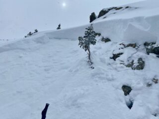
Avalanche Observations
| # | Date | Location | Size | Type | Bed Sfc | Depth | Trigger | Comments | Photo |
|---|---|---|---|---|---|---|---|---|---|
| 1 | Past 24 hours |
No Name E 12,200 |
D1 | SS | N-Natural | Visibility was generally poor but this looked to be a small pocket of soft slab that pulled from steep upper elevation east-facing terrain just below a rock band and entrained new snow. It appeared to be D1 in size and ran for maybe 100-150ft before stopping. | None | ||
| 2 | Today |
East Facing Near Treeline E 11,600 |
D1 | SS | O-Old Snow | 12" |
AS-Skier r-Remote |
|
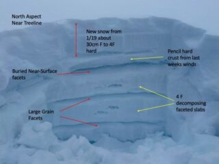
Snowpack Observations
See attached photo.
Avalanche Problems
| Problem | Location | Distribution | Sensitivity | Size | Comments |
|---|---|---|---|---|---|
 Persistent Slab
|
|
||||
 Wind Slab
|
|