Professional Observation
Basic Information
Observation Details
Observation Date:
January 14, 2021Submitted:
January 14, 2021Observer:
TAC - Andy BondZone or Region:
Taos AreaLocation:
High Traverse and Upper WaterfallSigns of Unstable Snow
Recent Avalanches?
None ObservedCracking?
None ExperiencedCollapsing?
None ExperiencedSnow Stability
Stability Rating:
GoodConfidence in Rating:
HighStability Trend:
SteadyBottom Line
Any slope with a hard slab should be considered suspect even if the likelihood might be low to trigger an avalanche. We have such fragile weak facets beneath these hard slabs that it's hard to put any trust in the snowpack right now, even if it's been a while since the last significant loading event. With the next snowstorm, we will see natural avalanches and a widespread avalanche cycle.
Media
Advanced Information
Weather Summary
Cloud Cover:
ClearTemperature:
16 - 26Wind:
Moderate , NWSunny windy day with NW winds in the 20 mph range. Snow was blowing around but seemed to be mostly eroding slopes rather than loading with just faceted snow blowing around
Snowpack Observations
Fun day out with Tom and glad to have the company. Skiing and riding is not that great right now. Below Treeline, we are melting away on solar aspects and north and shady aspects are completely faceted cohesionless snow that even on fat boards, you're sinking all the way to the ground. Ground hazards are a real issue right now.
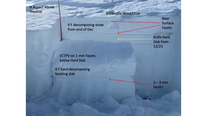
Moderate to strong NW winds over the last 24 hours have created breakable wind crusts above treeline and slopes exposed to wind near treeline. You know it's bad skiing when we joke about breakable wind crust being better than the faceted snow below treeline. Sun and warm temperatures over the last several days have created crusts on solar aspects. South aspects have been melting away back to bare ground.
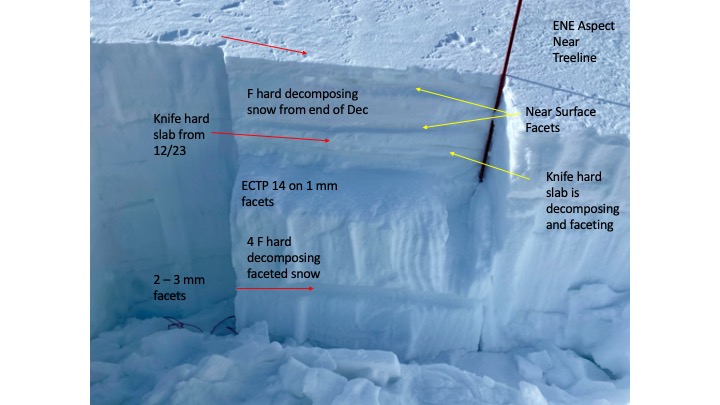
We're in the doldrums of high pressure and the snowpack structure isn't changing all that much. NW through E aspects mainly above treeline still harbor a poor snowpack structure of strong hard slab over weak faceted snow. With continued high-pressure, our facets are getting weaker and the hard slab continues to remain. You'll probably hear this more over the weekend before we are expecting a storm, but the snowpack we currently have will not stand much of a chance to any kind of loading.
Avalanche Problems
| Problem | Location | Distribution | Sensitivity | Size | Comments |
|---|---|---|---|---|---|
 Persistent Slab
|
|
We continue to get failure on isolation or easy results in our stability tests failing on weak faceted layers. Although stubborn to trigger an avalanche since the last loading Dec 29, it's hard to put much trust in the overall snowpack structure we have. Seems like it's right place right time and you may get a slope to avalanche. Looking a head to our next storm, this snowpack will easily fail with any bit of a new snow load! |