Professional Observation
Basic Information
Observation Details
Observation Date:
January 8, 2021Submitted:
January 8, 2021Observer:
TAC - Andy BondZone or Region:
Taos AreaLocation:
Yours and Mine Avalanche PathsSigns of Unstable Snow
Recent Avalanches?
None ObservedCracking?
None ExperiencedCollapsing?
None ExperiencedSnow Stability
Stability Rating:
Very GoodConfidence in Rating:
HighStability Trend:
SteadyBottom Line
Triggering an avalanche today would be difficult, but with new snow in the forecast for the weekend we have several weak layers of concern that won't easily accept any additional load. As we turn the page on high-pressure with a storm starting tomorrow. Avalanche danger will increase as we head into Sunday!
Media
Advanced Information
Weather Summary
Cloud Cover:
ClearTemperature:
20 - 27Wind:
Calm , WWarm day in the sun but cold in the shade. No snow transporting with calm to light west winds.
Snowpack Observations
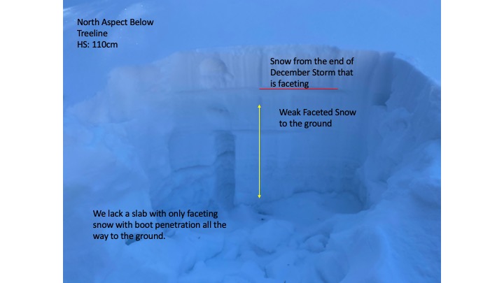
Below treeline we continue to find a mostly faceted snowpack with boot and sometimes ski penetration all the way to the ground. Solar aspects have felt the impacts of our intense sun this far south and snow especially below 10,000' on these aspects.
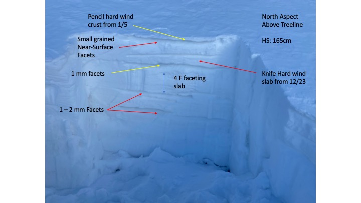
Near and above treeline there are various forms of slabs, crusts and multiple faceted layers that have not been healing over these last two weeks of high pressure. There are two weak layers of concern with new snow in the forecast for the weekend. A small wind crust formed on Tuesday with small-grained near-surface facets just below that is incredibly weak and will not stand up to much weight or any cohesive slab on top.
Larger facets below the knife hard wind slab from 12/23 continue to show signs of not healing with the ability to propagate. These two weak layers will the be the biggest concerns to be triggered if or when we do get new snow this weekend. Below that we have weak faceted snow throughout much of the snowpack. Like we saw during the last avalanche cycle at the end of December, there is a good likelihood that an avalanche can or will step down into these deeper weak layers.
Avalanche Problems
| Problem | Location | Distribution | Sensitivity | Size | Comments |
|---|---|---|---|---|---|
 Persistent Slab
|
|
Continue to find a poor snowpack structure on NW - E aspects Near and Above Treeline but triggering an avalanche would be very difficult even with easy to moderate stability test results. |