Professional Observation
Basic Information
Observation Details
Observation Date:
November 30, 2020Submitted:
November 30, 2020Observer:
TAC - Andy BondZone or Region:
Taos AreaLocation:
Sin Nombre AreaSigns of Unstable Snow
Recent Avalanches?
None ObservedCracking?
None ExperiencedCollapsing?
None ExperiencedSnow Stability
Stability Rating:
GoodConfidence in Rating:
HighStability Trend:
ImprovingBottom Line
Avalanche danger exists on N through E aspects above treeline. We have a poor snowpack structure on many of these slopes and are playing with buried facets and hard slabs. We're moving further away from the last significant loading event and triggering an avalanche is becoming increasingly difficult. Before committing to a line on a N through E aspect above treeline take the time dig down into the snow to assess if this snowpack structure exists.
Media
Advanced Information
Weather Summary
Cloud Cover:
ClearTemperature:
17 - 26Wind:
Calm , WSunny beautiful day with calm winds and no snow being transported. Was cold in the shade and felt downright hot in the sun.
Snowpack Observations
Those of you who are submitting observations, we can't thank you enough. I know sometimes it feels we focus on other aspects than West and South, but right now avalanche concerns are on North and East aspects. It's great to see all the tracks out there and stay safe. We appreciate all the observations and keep them coming!
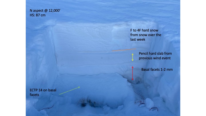
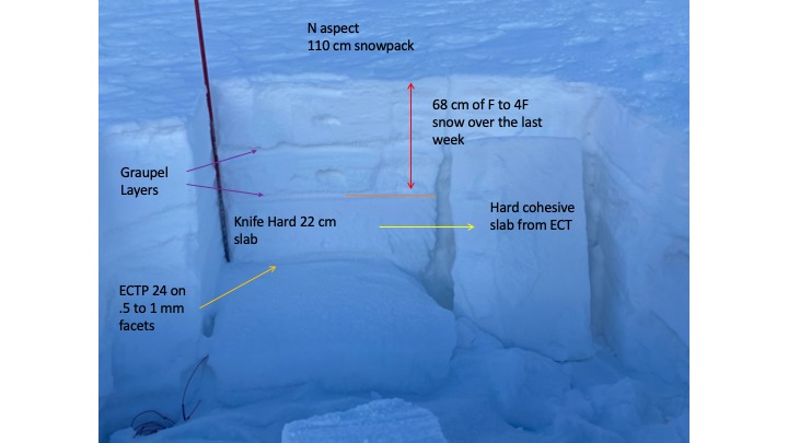
We continue to get more observations on Northerly aspects above treeline to gauge the depth and distribution on the persistent slab avalanche problem in our range. Above treeline, our wind-driven snow climate has a deeper snowpack overall and hard slabs from the 11/8 wind and snow event. These hard slabs are buried under roughly a foot of noncohesive snow from the 11/23-24 and 11/28 storms. Various forms of faceting is happening underneath the hard slab from older snow from October.
We continue to get moderate to hard force to initiate failure and propagation on these weak faceted layers. As we move further away from the last significant loading event (11/23-24) and natural and skier-triggered avalanches it is becoming increasingly harder to trigger an avalanche on these slopes. It doesn't mean it's impossible but moving towards unlikely.
Below treeline the snowpack is melting away quickly even with temperatures not getting above freezing during the day. Solar aspects are taking the brunt of this with South and West melting back to bare ground below 10,000'.
Near Treeline north aspects are quickly faceting and turning into cohesion-less facets, but some of the best skiing and riding can be found on these aspects and elevations in wind-shelterd areas.
It's about to be December and even though it's early season it's hard to complain about the conditions we currently have.